
Mathematics classroom notes
Year 10 - Coordinate geometry proofs
Strand / topic: Measurement and Geometry / Coordinate geometry proofs
Based on Pi Leo Academy's Victorian Curriculum F-10 Mathematics year-level guide and aligned to NAPLAN-style mathematical reasoning. Official curriculum code: Not stated in the provided curriculum source.
By the end of this note, students should be able to explain coordinate geometry proofs, use a clear method, solve simple and test-style questions, and check their answers for Year 10 Measurement and Geometry work.
It builds number sense, reasoning and confidence for classwork, quizzes and problem solving. This topic builds the reasoning, fluency and confidence students need for future NAPLAN-style questions and everyday mathematics.
Where is it on the map?
Coordinates tell us a position in a clear order.
For (3, 2), go 3 across and 2 up.
For Year 10, focus on understanding the idea before rushing to the final answer.
Think about it: maps, games and seating plans all use location clues.
Use this visual to organise coordinate geometry proofs before calculating.
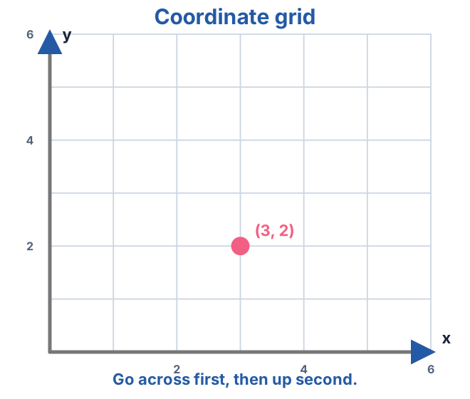
Go across first, then up or down.
What you need to know for this topic
Use this as a study checklist before trying quizzes, worksheets or NAPLAN-style questions.
Location
- read grid references
- read coordinates in order
- plot points
- use coordinates as map locations
Scale and maps
- read map scales
- compare distances
- use rows and columns
- describe a route clearly
1 What this means
Coordinates and maps tell us exactly where something is. Start by learning to read the horizontal position first and the vertical position second. A helpful visual is a coordinate grid with axes and scale labelled. For example, this idea can be used when solving a practical or unfamiliar problem about coordinate geometry proofs.
Coordinates and maps use ordered directions, so the order of the information matters. In Year 10, students should first ask, 'What is the question really asking me to find?' Then they can draw a picture, make a table, use a number line, write a formula or build an equation. The final answer should match the story, the units and the size of the numbers.
- Read the horizontal direction first, then the vertical direction.
- Check the scale before reading a map, graph or grid.
- Use ordered pairs or grid references exactly as the question asks.
- Return to the context after locating the point.
2 Important rules / ideas
For coordinates, read the horizontal value before the vertical value.
Every map or grid may use a different scale.
(3, 5) and (5, 3) usually describe different locations.
Important vocabulary
A number pair or grid reference showing position.
A reference line on a graph or grid.
The starting point on a coordinate plane.
The relationship between a drawing and the real distance.
3 Step-by-step method
- Read the scale and axes.
- Move along the horizontal direction first.
- Move vertically second.
- Check the point or location matches the question.
4 Worked examples
Plot the point (3, 2).
- Move 3 across on the horizontal axis.
- Move 2 up on the vertical axis.
- Mark the point.
What is the coordinate of a point 5 across and 4 up?
- The x-coordinate is 5.
- The y-coordinate is 4.
- The coordinate is (5, 4).
Find the midpoint of (2, 4) and (8, 10).
- Average the x-values: (2 + 8) / 2 = 5.
- Average the y-values: (4 + 10) / 2 = 7.
- Midpoint = (5, 7).
A map scale says 1 cm represents 2 km. How far is 4 cm?
- Each centimetre represents 2 km.
- 4 x 2 = 8.
- The real distance is 8 km.
5 More examples
What does (6, 2) mean?
Move 6 across, then 2 up.
1 cm represents 5 km. What does 3 cm represent?
3 x 5 = 15 km.
NAPLAN-style thinking
In NAPLAN-style questions, coordinate geometry proofs may appear as a short calculation, a word problem, a diagram, a table or a multi-step reasoning question. Students should slow down and decide what the question is really asking before calculating.
Estimate first and eliminate answers that are too small, too large or use the wrong unit.
Write only the answer required, but use working on paper to avoid mental slips.
Circle the numbers, underline the action words and decide whether all numbers are needed.
Do one step at a time and label intermediate answers so the final step is clear.
6 Common mistakes
Read the final sentence before calculating.
Name the topic and method before starting.
Estimate or use inverse operations to check.
- Choosing the first operation seen in the wording.
- Forgetting units, labels or place value.
- Stopping after the first step when the question asks for a final comparison.
7 Tips to remember
The first coordinate is horizontal.
One square may not equal one unit.
After finding a location, answer in words too.
Parent teaching tips
- Ask your child to explain the method aloud before writing the answer.
- Use a real-life context at home, such as shopping, cooking, sport scores, maps or timetables.
- Praise clear working and checking, not only speed.
- Ask your child to write the formula or rule first, then substitute values carefully.
Remember
For coordinate geometry proofs, identify the question type, choose a clear method, show working and check the answer.
8 Quick practice
- Plot the point (3, 2).
- What is the coordinate of a point 5 across and 4 up?
- Find the midpoint of (2, 4) and (8, 10).
- A map scale says 1 cm represents 2 km. How far is 4 cm?
9 Answers / explanation
Question 1
Answer: Mark the point.
Move 3 across on the horizontal axis. Move 2 up on the vertical axis. Mark the point.
Question 2
Answer: The coordinate is (5, 4).
The x-coordinate is 5. The y-coordinate is 4. The coordinate is (5, 4).
Question 3
Answer: Midpoint = (5, 7).
Average the x-values: (2 + 8) / 2 = 5. Average the y-values: (4 + 10) / 2 = 7. Midpoint = (5, 7).
Question 4
Answer: The real distance is 8 km.
Each centimetre represents 2 km. 4 x 2 = 8. The real distance is 8 km.
Extension challenge
Create your own multi-step question for this topic using an Australian context, then solve it and explain each step.
Hint: Use shopping, sport, maps, timetables, weather, school events or measurement at home.
Answer guide
Answers will vary. A strong answer includes clear working, correct units and a final sentence.
Quick revision
- Know what coordinate geometry proofs is asking you to find.
- Choose a diagram, table, formula, number line or equation before calculating.
- Show enough working that you can find and fix mistakes.
- Check the final answer, units and reasonableness.